A recent report by Forensic Architecture, a multidisciplinary research organization, and released by the Drop Site News on Saturday, indicates that the regime has established no fewer than 13 new military outposts within Gaza since the ceasefire was implemented on October 10. Additionally, there has been a significant acceleration in the expansion and consolidation of 48 existing outposts. The report indicated that Israeli forces were not just occupying temporary positions, but actively transforming the landscape in a manner consistent with establishing prolonged control. An examination of satellite imagery dated between October 10 and December 2 reveals that the regime has developed an extensive network of military infrastructure to the east of the “yellow line,” a boundary purportedly marking a partial withdrawal zone established under the ceasefire agreement. Researchers have reported that Israeli forces are in command of over half of Gaza and are continuing to expand their control through ongoing construction and demolition activities. Forensic Architecture reports that the regime has developed an expanded network of roads connecting military installations within Gaza to Israeli bases, roads, and unauthorized settlements beyond the coastal enclave. This infrastructure enhances logistical coordination between occupied areas in Gaza and the territories under Israeli occupation. The organization has reported ongoing construction of a new road in Khan Younis, located in the southern region of Gaza. This development reroutes the regime’s Magen Oz military corridor, ensuring it runs entirely within territory under the regime’s control. The military buildup has coincided with an organized demolition of Palestinian property, notably in eastern Khan Younis and other parts of southern Gaza such as Rafah. Following the ceasefire, structures that had previously remained intact were subsequently demolished. In their place, new outposts and military roads have been established throughout the affected regions. A report has highlighted a case study involving the establishment of a new Israeli outpost in Jabaliya, located in northern Gaza. In this instance, a densely populated area of tents was dismantled, and surrounding structures were demolished. Recent satellite imagery and on-the-ground photographs reveal the development of roads, substantial militarized barriers, and newly erected structures on elevated terrain east of the “yellow line,” which provides a vantage point over regions from which Palestinians have been forcibly displaced. Mouin Rabbani, a former United Nations official and senior analyst on Israeli-Palestinian issues, indicated that the findings are consistent with the regime’s longstanding strategy of establishing irreversible conditions on the ground. He informed Drop Site News that Tel Aviv has consistently adopted gradual measures that solidify over time, particularly when global pressure diminishes or the political implications are considered acceptable. In the preliminary stage of the ceasefire connected to Trump’s 20-point Gaza proposal, Israeli forces were set to retract to the “yellow line,” resulting in between 53% and 58% of Gaza remaining under Israeli control, as outlined in official maps released by Washington and subsequently by the Israeli military. Forensic Architecture has reported that subsequent to the ceasefire, the regime has expanded its territory by installing at least 27 physical markers beyond the “yellow line” depicted on its own cartographic representations. Trump’s proposal outlines that the regime will refrain from occupying or annexing Gaza, with a commitment to eventual withdrawal. This move would pave the way for an “International Stabilization Force” to assume responsibilities in the region. The report determined that the development of outposts, the integration of road networks, and the ongoing demolition of Palestinian neighborhoods are actions reinforcing a presence in Gaza that exceeds mere “security measures,” indicating a more permanent establishment in the region.
Satellite imagery indicates Israel is laying the groundwork for a permanent military presence across large parts of the Gaza Strip, according to a new analysis documenting extensive construction, infrastructure expansion and continued destruction of Palestinian property.
The research, released by the multidisciplinary group Forensic Architecture and published by Drop Site News on Saturday, found that the regime built at least 13 new military outposts inside Gaza after the ceasefire came into force on October 10 and accelerated the expansion and consolidation of 48 existing outposts.
The findings suggest Israeli forces are not merely holding temporary positions but are physically reshaping Gaza in ways consistent with long-term control.
The analysis, based on satellite images taken between October 10 and December 2, shows the regime maintaining a dense network of military infrastructure east of the so-called “yellow line,” a partial withdrawal boundary set under the ceasefire.
Researchers said Israeli forces now control more than half of Gaza and have continued to extend that control through ongoing construction and demolition activity.
According to Forensic Architecture, the regime has expanded road networks linking military outposts inside Gaza to Israeli bases, roads and illegal settlements outside the coastal enclave, reinforcing logistical integration between occupied areas in Gaza and the occupied Palestinian territories.
The group documented continued construction of a new road in Khan Younis in southern Gaza that reroutes the regime’s Magen Oz military corridor to run entirely within areas under its control.
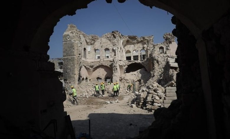
Military expansion has been accompanied by systematic destruction of Palestinian property, particularly in eastern Khan Younis and elsewhere in southern Gaza, including Rafah.
Buildings that had not previously been destroyed were demolished after the ceasefire, while new outposts and military roads were constructed across the same areas.
One case study cited in the report detailed a newly established Israeli outpost in Jabaliya in northern Gaza, where a densely populated tent area was dismantled and surrounding buildings were razed.
Satellite imagery and ground photographs showed the construction of roads, large militarized berms and new structures on elevated ground east of the “yellow line,” overlooking areas from which Palestinians were forcibly displaced.
Meanwhile, Mouin Rabbani, a former United Nations official and senior analyst on Israeli-Palestinian issues, said the findings were consistent with the regime’s long-standing strategy of creating irreversible facts on the ground.
He told Drop Site News that Tel Aviv had consistently pursued incremental steps that become permanent once international pressure fades or political costs are judged manageable.
Under the initial phase of the ceasefire linked to US President Donald Trump’s so-called 20-point Gaza plan, Israeli forces were meant to withdraw to the “yellow line,” leaving between 53% and 58% of Gaza under Israeli control, according to official maps released by Washington and later by the Israeli military.
However, Forensic Architecture found that since the ceasefire the regime has seized additional land by placing at least 27 physical markers west of the “yellow line” shown on its own maps.
Trump’s plan states that the regime would not occupy or annex Gaza and that its forces would eventually withdraw as an “International Stabilization Force” takes over.
The report concluded that through the expansion of outposts, integration of road networks and continued demolition of Palestinian neighborhoods, the regime is entrenching a presence that goes beyond temporary “security measures” and points to a permanent role on the ground in Gaza.